Lab Services
Lab capabilities
The Arctic Coastal Geoscience Lab works to provide a variety of services that support the study of Alaska’s coastlines.
The lab also provides a variety of fee-based services in relation to sediment core and coastal hazard analysis.
Sediment core services include their collection in lake, coastal, and marine environments. Lab analysis includes logging, loss-on-ignition, particle size analysis. radiometric dating and age depth modeling.
We work with rural Alaska coastal and riverine communities to address local priorities regarding coastal mapping and hazards. We also develop long-term partnerships that lead to community-based environmental monitoring that supports local decision-making and planning and needs.
Please email for additional information and cost estimates on all services.
Our lab is equipped with the following:
- Canberra Broad Energy Germanium (BEGe) Detector
- Beckman Coultier LS 13 320 Laser Diffraction Particle Size Analyzer
- Thermo Scientific Thermolyne Muffle Furnace
- Various marine, terrestrial, and aquatic sediment coring systems
- MALA Ground Explorer HDR Ground Penetrating Radar
- Trimble Geospatial surveying instruments and software
- Aerial Drone Surveys and Structure from Motion data products
Geospatial change detection analysis
- High precision scales
- Wild Heerbrugg Microscope
- Bartington Magnetic Susceptibility Meter M.S.2
Coastal hazard analysis
We build sustainable partnerships with tribal environmental programs to address local science priorities. We develop baseline data sets and assessments of historical shoreline change rates through repeat visits that include topographic surveys, community meetings, and other research and education tasks.
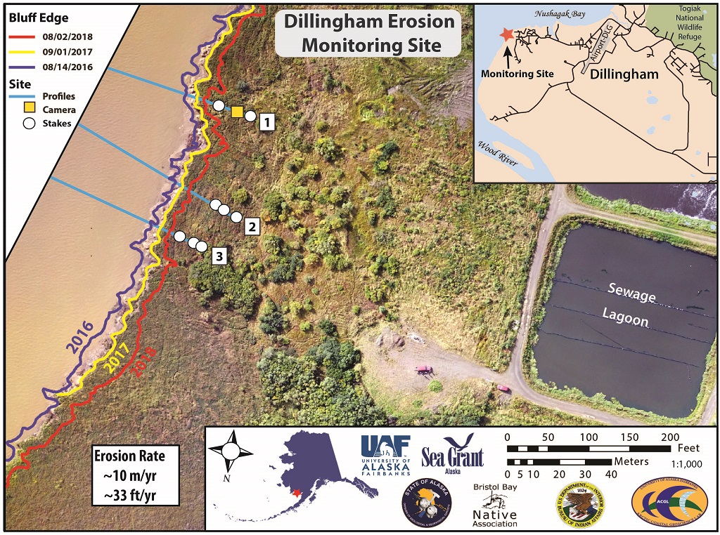
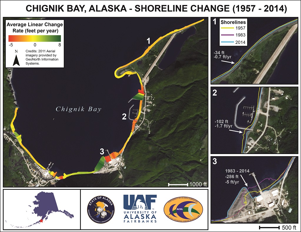
Below is an example video that would be presented after obtaining photos with a time-lapse camera. The photos can then be used to determine the change in shoreline position as well as the driving mechanisms behind the measured change. Two maps showing the change in shorelines of Dillingham and Chignik Bay are also shown below.
Topographic and GNSS services
We collect real-time kinematic (RTK), post-processed-kinematic (PPK), and fast static GNSS data with our survey grade Trimble Surveying System. The data we collect is sub-centimeter to centimeter grade accuracy and can be used for various applications such as ground control points, coastal elevation profiles, mobile base station establishment, infrastructure mapping, coastline delineation and volumetric change..
We are commercially licensed to collect aerial imagery with our fleet of unmanned aerial vehicles. We limit these services to hot spot areas of environmental change and infrastructure risk. This data feeds into photogrammetric software such as Agisoft MetaShape, where georeferenced ortho-corrected mosaics and digital surface models (DSM) are constructed using structure-from-motion (SfM).
Geophysical surveys
We collect ground-penetrating radar (GPR) data with our MALA GroundExplorer HDR using 180 MHz and 450 MHz antennas to image the subsurface features and architecture. This state-of-the-art user-friendly MALA system has a built-in differential GPS system and can be applied to a variety of applications in research, education and industry. Below are examples of products that can be made using GPR.
Gamma spectroscopy
We run unconsolidated sediment samples on our Gamma Detector. The instrument is a BeGe 38/30 Germanium detector. The software system is the Genic-2000 Analytical & Analysis package. Our detector is capable of running sediment samples with a mass typically between 5-10g (or up to the full volume of the sample dish). Samples are run in plastic petri-dish sealed with electrical tape. Genie-2000 output files are post-processed to identify the nuclides of interest and activity levels according to the specifications of each project. Our services will provide you with an Excel datasheet of results for each sample submission.